
The Dolphinfish Research Program had a most successful year in 2014. The program is closing in on 2,100 fish tagged as late tagging reports are received. There have been 49 reports of tags being recovered and we’ll likely see more 2014 fish show up in 2015. Two satellite tags deployed off Charleston, SC, showed the two extremes encountered when using these expensive instruments on dolphinfish. One fish carried the instrument for only 36 hours before being eaten by a predator. The other tag stayed with the fish for the full 180 days, the longest period that a dolphin has been tracked using this technology. Additionally, four technical papers reporting on findings of this research program appeared in peer-review journals, sharing our findings with the scientific community. Overall, the 2014 study was amazingly successful scientifically.
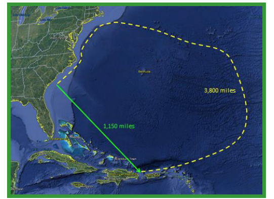
The Dolphinfish Research Program (DRP) has hit a home run in its first effort to document the long-term travels of dolphinfish found off the U.S. east coast thanks to a grant from the Guy Harvey Ocean Foundation. On June 3, 2014, two satellite tags programmed for six-month monitoring periods were deployed on two bull dolphin. They were released 63 miles southeast of Charleston, South Carolina, during a fishing trip aboard the sports fishing vessel My Three Sons, owned by Hunter Edwards of Charlotte, North Carolina. One of these tags has surfaced after 180 days, 44 miles northeast of Punta Cana, Dominican Republic.
The satellite tag has been uploading the data that it collected during the 180 days that it stayed with the dolphinfish. The information is uploaded to the ARGOS satellite and transmitted in a binary code format. The instrument may transmit data for as long as 30 days. The biggest threat to the transmission of the information is for the instrument to lie over on its side by washing ashore or being caught up in flotsam or Sargassum. It is unable to transmit in this position. After one week of no contact, following the 30 days transmission allowance, the tag manufacturer will be requested to decompress the data and provide an initial analysis.
The information contained in the data from this tag will provide the first look at the movement route of a dolphinfish travel up the U.S. East Coast and the route it took to reach the Caribbean islands. No prior research program has attempted to document this amazing travel. We have speculated about the southerly oceanic route used; now we will get our first look at one. I, for one, can hardly wait to see the results.
While this instrument is uploading its data, it is serving as an ocean surface current drifter buoy, monitoring the surface currents. With less than a quarter inch of the top of the body of the tag and the thin antennae wire above the water surface, there is minimal sail available to allow the wind to affect the unit drift. As of December 22, 2014, the tag had drifted at rates of 5 to 33 miles per day and was located 163 miles south of Isla Mona, in the open Caribbean Sea. Its direction of travel has ranged from southeast to southwest and is currently traveling in a southwesterly direction.
This drift pattern shows how ocean currents in some regions can have significant changes in their direction and flow speed from season to season and year to year. Previous PSATs used on dolphin in this region of the Caribbean showed a southwest drift in May 2011 and a westerly drift in March 2014. Such changes in the current flow can affect the distribution of dolphin and other oceanic pelagic species among the Caribbean islands.
A grant from the Guy Harvey Ocean Foundation provided funding for the purchase of five satellite tags to begin the second phase in the tracking of dolphinfish: long-term tracking of East Coast fish. As part of this study, three more satellite tags will be deployed in the spring of 2015. With luck we could have another satellite tag from the east coast surface off a Caribbean island.
 For More Information, Contact
Don Hammond
Dolphinfish Research Program
Cooperative Science Services, LLC
961 Anchor Rd., Charleston, SC 29412
Telephone FAX (843) 795-7524
Email [email protected]
Web site www.dolphintagging.com
For More Information, Contact
Don Hammond
Dolphinfish Research Program
Cooperative Science Services, LLC
961 Anchor Rd., Charleston, SC 29412
Telephone FAX (843) 795-7524
Email [email protected]
Web site www.dolphintagging.com
For more Dolphin Tagging news Click Here


